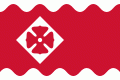
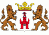
Oudewater
 |
 |
The origin of the town of Oudewater is obscure and no information has been found concerning the first settlement of citizens. It is also difficult to recover the name of Oudewater. One explanation is that the name is a corruption of old water-meadow. Oudewater was an important border city between Holland and Utrecht. Oudewater (lit. "Old water") was of great strategic importance.
The town was granted city rights in 1265 by Hendrik van Vianden, the bishop of Utrecht.
Oudewater took its place in the First Free States council in Dordrecht on 19 July 1572, Oudewater was one of the twelve cities taking part in the first free convention of the States General in Dordrecht. This was a meeting that laid down the origin of the State of the Netherlands, as we know it now, under the leadership of the House of Orange. This happened at the beginning of the Eighty Years' War (1568–1648) when the Netherlands were still part of the Spanish Empire. After a Siege of Oudewater, the city was conquered by the Spanish on 7 August 1575, and most of its inhabitants were killed, including the family of famous Oudewater native and Protestant theologian Jacobus Arminius (1560-1609).
In the 16th and 17th century, Oudewater was an important producer of rope. In the surrounding area, hemp was cultivated. There still is a rope manufacturing plant and a rope museum in the town.
In 1970 the municipality of Oudewater moved from the province of South Holland to the province of Utrecht.
Map - Oudewater
Map


Country - Netherlands
 |
 |
The four largest cities in the Netherlands are Amsterdam, Rotterdam, The Hague and Utrecht. Amsterdam is the country's most populous city and the nominal capital. The Hague holds the seat of the States General, Cabinet and Supreme Court. The Port of Rotterdam is the busiest seaport in Europe. Schiphol is the busiest airport in the Netherlands, and the third busiest in Europe. The Netherlands is a founding member of the European Union, Eurozone, G10, NATO, OECD, and WTO, as well as a part of the Schengen Area and the trilateral Benelux Union. It hosts several intergovernmental organisations and international courts, many of which are centred in The Hague.
Currency / Language
| ISO | Currency | Symbol | Significant figures |
|---|---|---|---|
| EUR | Euro | € | 2 |
| ISO | Language |
|---|---|
| NL | Dutch language |
| FY | West Frisian language |